Carstensz Pyramid - © Philippe Gatta

Carstensz Pyramid 4884 m, West Papua

Carstensz Pyramid is the highest peak of the seventh continent (Australia/Oceania). The route is technically easy but with the rebels, the political situation and the gold mine close by, getting to the mountain has been a major challenge… After Carstensz’ ascent, Philippe became the 7th Frenchmen to complete the 7 Summits challenge.

Carstensz Pyramid (4884 m / 16,024 ft)

West Papua, Indonesia

Carstensz Pyramid (© P. Gatta)

Carstensz Pyramid (Puncak Jaya), 4884m (16,024 ft)

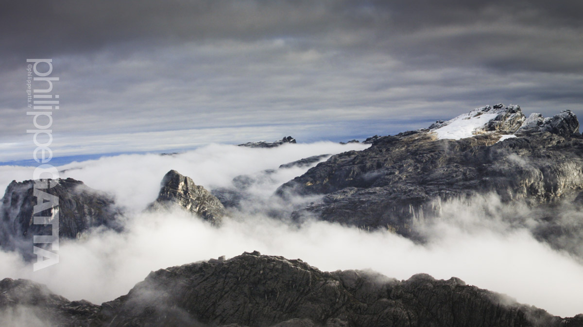
Carstensz Pyramid, is the highest mountain in the Pacific Basin, and is considered the highest peak of the seventh continent (Australia/Oceania) for climbers attempting the Seven Summit. The peak is located in the Sudirman Range composing the western central highlands of Indonesia's Papua province (island of New Guinea). It is the highest point between the Himalayas and the Andes and the highest island peak in the world.

Puncak Jaya is also called Carstensz Pyramid, after Dutch explorer Jan Carstensz who first sighted the glaciers on the peak of the mountain in 1623. The peak was first climbed in 1962 by Heinrich Harrer, Temple, Kippax and Huizenga.

Much of Sudirman Range is characterized by easy terrace, surmounted by severe rock walls. Carstensz Pyramid's North face is comprised of sheer 10,000 foot cliffs which embrace an extensive ice wall glacier.

The route on Carstensz Pyramid follows a series of gullies up the north face for 500m (1,640 ft) of solid rock before breaking out on the ridge. Riddled with notches, the summit ridge undulates for half a kilometer. The descent requires rappels and down climb most of the way. The rock is extremely good, rarely loose, and always provides good friction even in wet weather. The rock climbing difficulty on Carstensz is up to 5.10 for short steeps.

Temperatures can range from -3ºC to 15ºC (25-60º F) with occasional sunshine in the mornings, then rainfall or snow in the afternoons and evenings. Winds are variable but can be strong.

Carstensz and Oceania map
Carstensz and Oceania map (Courtesy NASA/JPL-Caltech)

Carstensz Pyramid Expedition


March 30: Base Camp - Carstensz Summit - Base Camp

We get up at 3am. There is a light rain and the temperature is around 5 ºC. I am dressed like I was at Vinson BC by -20 ºC the humidity here makes a big difference.

We start at 4:30am. We climb 100m to a pass (on the left on the photo below) and go down to a small valley.

We pass a few lakes (see photo below) and reach the bottom of Carstensz's wall at 4350m, it is 5:30am.

Lake at Carstensz's base camp (© P. Gatta)

Trail from the first pass above BC to Carstensz's face (© P. Gatta)

The rain has stopped, we put harness and helmet on, let a pack and start the climb. I lead followed by Angelo and Danny. There are fixed lines in place. The first 3 pitches are steep but not hard (see photo below). The rock is of quite good quality and very adherent even wet. At the top of those pitches there is a shelf and from there are 50m of scree and easy terrain. Above there are 2-3 pitches of slabs (60 degrees) and gullies where the water is pouring.

On top of those slabs, there is again a steep scree for around 40m. The snow is covering the scree and it is a bit slippery. From that point on, we had 5 to 10cm of snow.
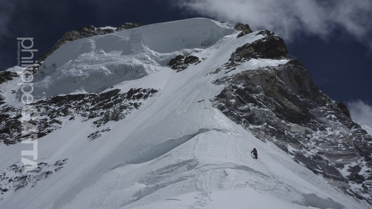
The clouds break and we can have a fantastic view over the Ngga Pulu (4862m), second highest summit of Oceania. From here we have a good view of the ridge and the Tyrolienne (see below).

Bottom of Carstensz's North Face, the route is in the center of the photo (© P. Gatta)
Bottom of Carstensz's Face, the route is in the center (© P. Gatta)

Carstensz's summit ridge seen from 4600m. The 1st gap and the Tyrolienne is visible (© P. Gatta)
Carstensz's summit ridge from 4600m. The Tyrolienne is visible (© P. Gatta)

Then there is another steep pitch which ends to an easy section. I make a mistake and traverse too the left too early. We waste here some times and energy until we finally reach the bottom of the final wall. This wall is 2-3 pitches high and quite steep. It ends on the ridge, just on the left of a big and obvious tower. A switch gloves as the first pair is completely wet.

Philippe high up on Carstensz. Ngga Pulu and other 4800m Peaks are visible behind. New Zealand pass is on the left (© P. Gatta)
Philippe high up on Carstensz. Ngga Pulu behind (© P. Gatta)

Carstensz summit ridge and Ngga Pulu (© P. Gatta)

We reach the ridge (4745 m) at 7:40am. We can see for the first time the South face of Carstensz and the forest beyond. Unfortunately the clouds are back.

We quickly reach the Tyrolienne which is the fastest way to pass the gap. Otherwise, we could rappel 8m, cross 10m and climb 10m on the other side. All this section of the ridge is covered with snow or ice. There are 4 ropes for the Tyrolienne and each of them has 2cm of ice all the way. I spend at least 10 minutes to break the ice as I go.

The Tyrolienne is the longest crossing, but that is not the only one gap. There are two other gaps where we have to climb down then up along the ridge.

A final section on the South face leads to the summit that we reached in 3h from the bottom.

We are in the clouds and see anything, a Carstensz standard I guess. This is for me the last of the Seven Summits. The weather deteriorates as we start the descent.

Carstensz Pyramid's summit (© P. Gatta)

We climb down and rappel the 500m of face in 2h30 and gently come back to the base camp.


Ngga Pulu, 4862 m (15,951 ft)

Ngga Pulu (also called Ngga Poeloe) is the second highest peak of Oceania. It is just 22 meters lower than Puncak Jaya (Carstensz). We scaled Ngga Pulu the day after Carstensz. The climb starts from the same base camp and follow the valley toward the East. We reached the "chaos of big rocks" in 45 minutes, from there we turned left toward the ridge of Ngga Pulu.

Close to the summit ridge of Ngga Pulu (© P. Gatta)

Slabs and Ngga Pulu's glacier  (© P. Gatta)
Slabs and Ngga Pulu's glacier (© P. Gatta)

After the ridge we followed the large slabs just East of the glacier.

We reached the top in 2h from the base camp.

Summit of Ngga Pulu'(© P. Gatta)
Summit of Ngga Pulu (© P. Gatta)

7 Summits Challenge

The Carstensz Pyramid is part of the 7 Summits Challenge which consists in climbing the highest mountain of each of the 7 continents.

On Key

Top Stories

Madagascar Race - © Philippe Gatta

Madagascar Race

The Madagascar Race is a 250 km (155 miles) running race which is part of 4 Deserts Roving Race series. The 2014 edition started in the north of Madagascar, close to the city of Antsiranana and went South – Soutwest to finish at the city of Ambilobe. There were 6 stages in 7 days: almost 4 Marathons in 4 days, then 77 km, a rest day and a final stage of 10 km.

Great Divide Trail - © Philippe Gatta

Great Divide Trail (GDT), 300 Km across Canada

After the GHT and the Via Alpina, Anna and Philippe left for another long traverse across the Canadian Rocky Mountains. They planned to run 600 km along the GDT but nothing went as planned : rain, snow storm, bears, mud, mosquitoes and injuries. Ultimately they made 300 km in harsh conditions.

Via Alpina - © Philippe Gatta

Via Alpina – 1000 Km across the Alps

Wishing to run across the Triglav, Dolomites, Tyrol, la Bavaria, Interlaken…, they decided to follow a combination of the red and green Trail of the Via Alpina. To limit the overall distance to 1,000 km, they decided to start in the Triglav National Park (Slovenia) and finish in Chamonix (France). From the Triglav, they followed the Red Trail across Italy, Austria, Germany to Lichtenstein. From there, they switched to the Green trail to Lenk in Switzerland. After Lenk, they made their own trail to Chamonix, France.

Ama Dabam - © Philippe Gatta

Ama Dablam 6856 m, Nepal

Ama Dablam, 6856 m, is an spectacular Nepalse peak, just a few kilometers South of Everest. Philippe and Jean-Marc climbed the Southwest Ridge. AS often off season, they were less than 10 climbers on the mountain.

Carstensz Pyramid - © Philippe Gatta

Carstensz Pyramid 4884 m, West Papua

Carstensz Pyramid is the highest peak of the seventh continent (Australia/Oceania). The route is technically easy but with the rebels, the political situation and the gold mine close by, getting to the mountain has been a major challenge… After Carstensz’ ascent, Philippe became the 7th Frenchmen to complete the 7 Summits challenge.